Complete Rental Car Guide (Self-Drive + Ferries)
Start: Santiago
This guide is designed strictly for travelers using a rental car.
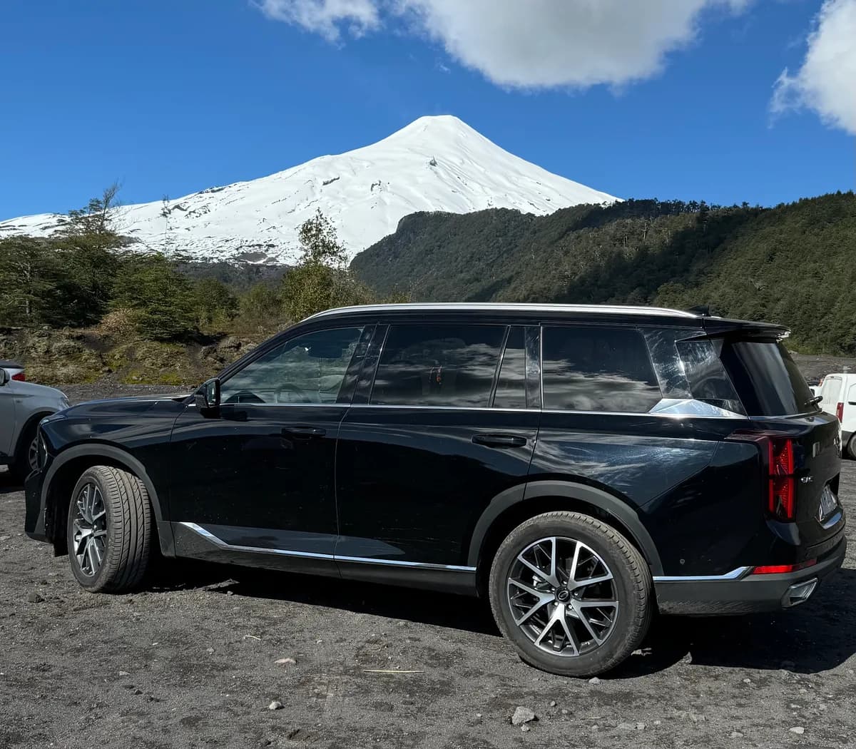
We rented a car for 8 months from RentCarChile. We switched to a Toyota RAV4 for our travels. The company was always responsive and carried out servicing on time. Reliability and willingness to help—you can count on the quality of service.
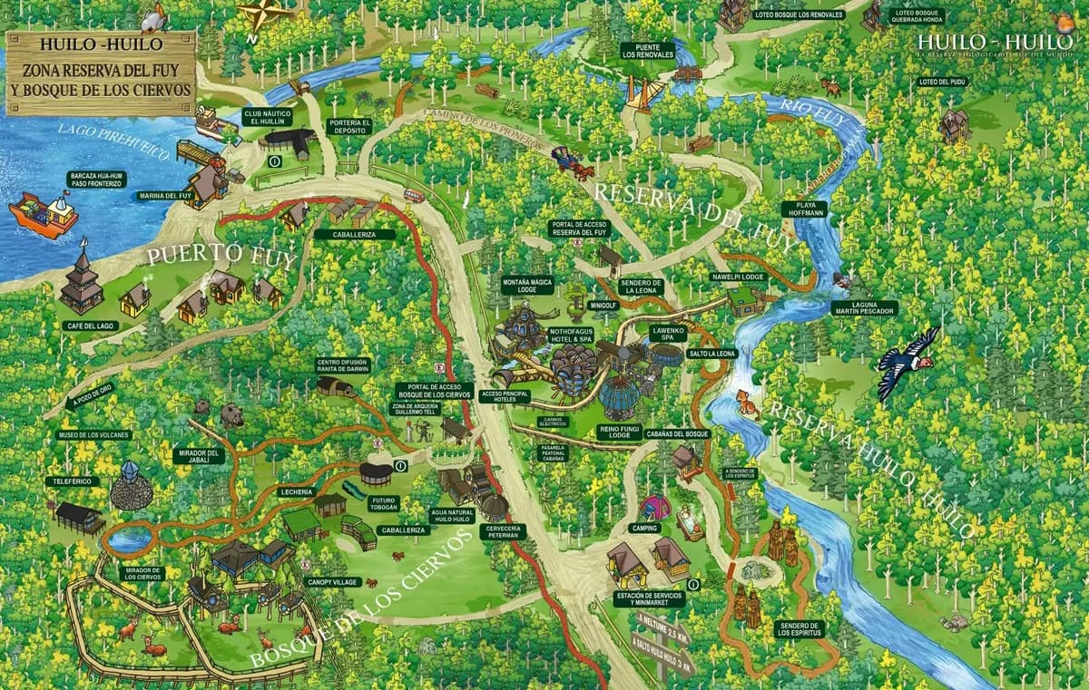
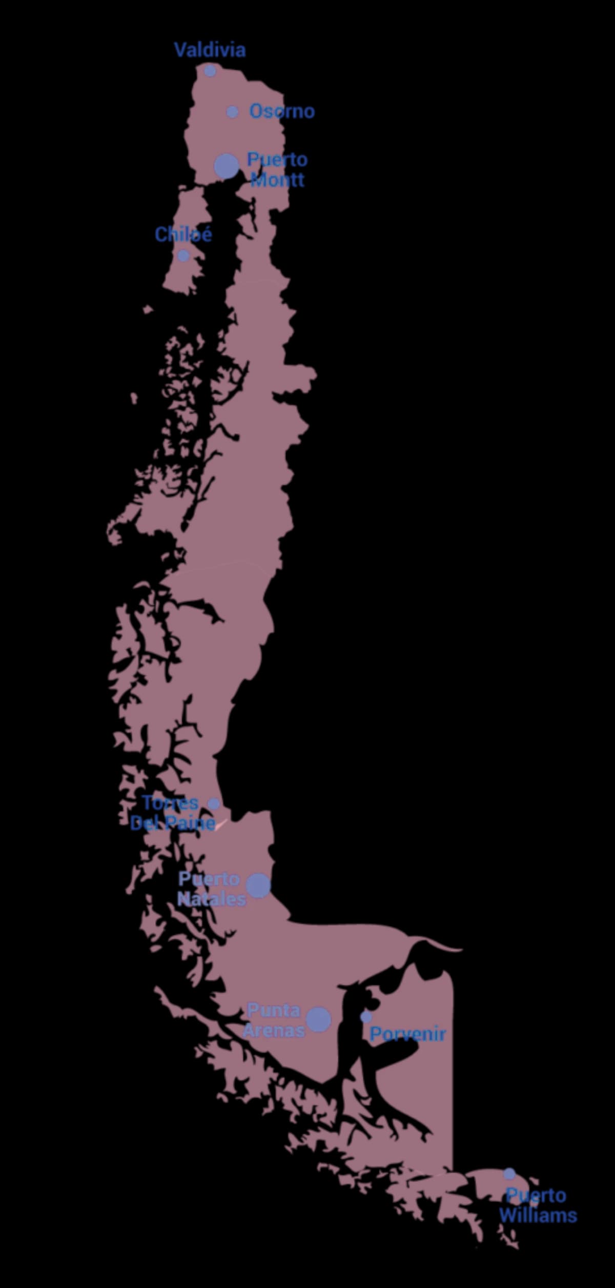
The map below gives you an overview of the full route.
This guide takes you from Santiago through Araucanía, the Lake District, and Patagonia—with ferries, national parks, and the Carretera Austral. Use the map here to see the full journey at a glance.
Below you will find the full day-by-day route with stops, tips, and links. Follow the sections in order to plan your trip and get the most out of your rental.
Always use your navigator when driving to locations—roads may be new or updated. This map is for your better understanding and visual simplicity of the route only.
Route: Santiago → Pucón. Best explored by car.
The drive from Santiago to Pucón is long but straightforward. Highways are in good condition, and the final stretch becomes greener and more mountainous as you approach the lake region. Having your own car here makes a big difference — distances between natural spots are short, but public access is limited without one.
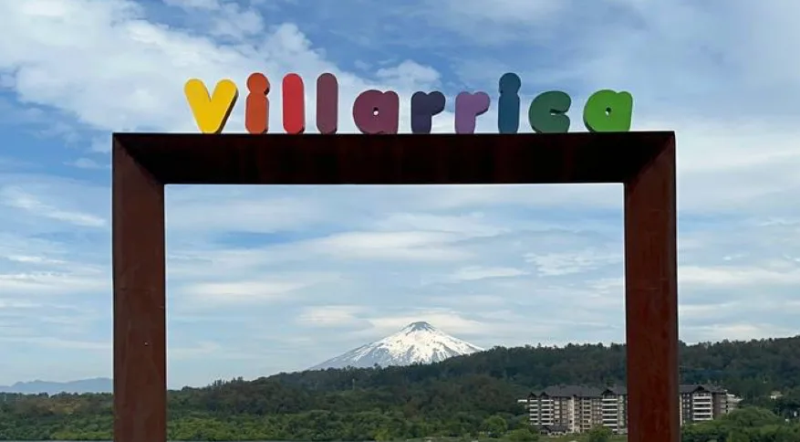
Pucón is where the trip shifts from driving to exploring. A small town wedged between a lake and an active volcano, it serves as the base for everything in the Araucanía — hot springs, forests, black sand, and high-altitude viewpoints are all within short driving distance.
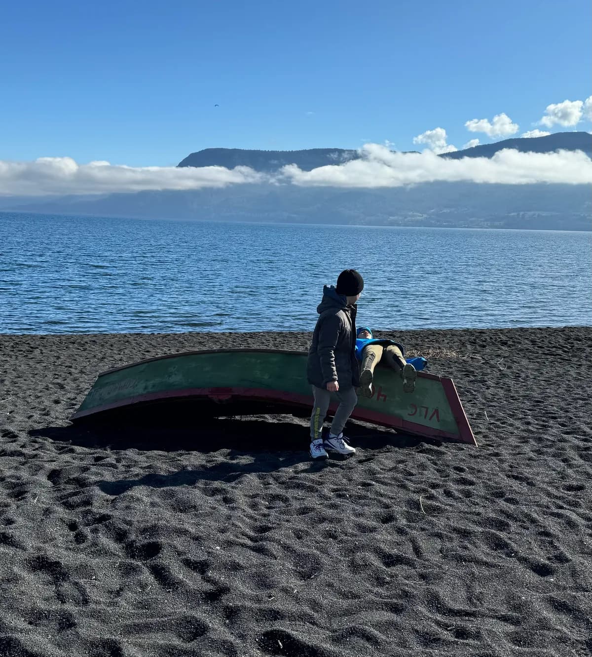
Lake Villarrica was formed by volcanic and glacial activity. It's large, clean, and usually calm in the mornings. The lake area is ideal for short lakeside walks, kayaking, and relaxing beach stops.
One of the most distinctive features of Pucón is its black sand beaches. The sand is made from fragmented volcanic rock. It absorbs heat quickly, so on sunny days it can be surprisingly warm under your feet.
Visually, the contrast is strong: dark sand, blue lake, snow-covered volcano, deep green forests. It creates a dramatic but very natural landscape.
Araucanía was historically Mapuche land. Unlike many other indigenous groups in South America, the Mapuche resisted Spanish colonization for centuries. The region was not fully integrated into the Chilean state until the late 19th century during the "Pacificación de la Araucanía."
This history explains why Mapuche culture remains visible, place names often have indigenous origins, and the connection to land and nature is strong. Understanding this adds depth to the experience of visiting.
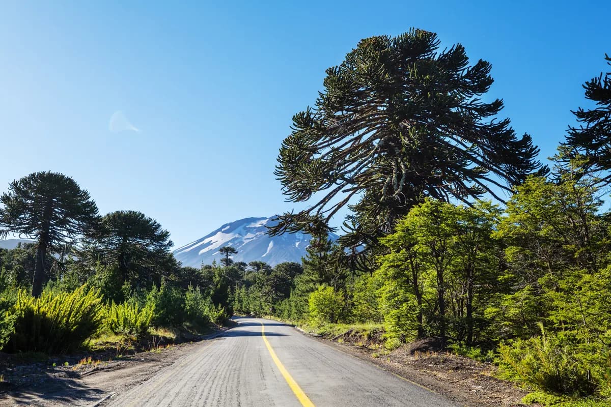
Driving around Pucón, especially toward higher elevations, you pass coihue forests, rivers fed by glacial melt, and araucaria trees at higher altitudes. The frequent rain keeps the region intensely green. Cloud movement around the volcano is constant, which means views can change quickly throughout the day.
Climate: Cold winters, frequent rain in shoulder seasons.
Map: Coñaripe / Cochelue Beach
~20 km drive. Road condition: Good, scenic lakeside route.
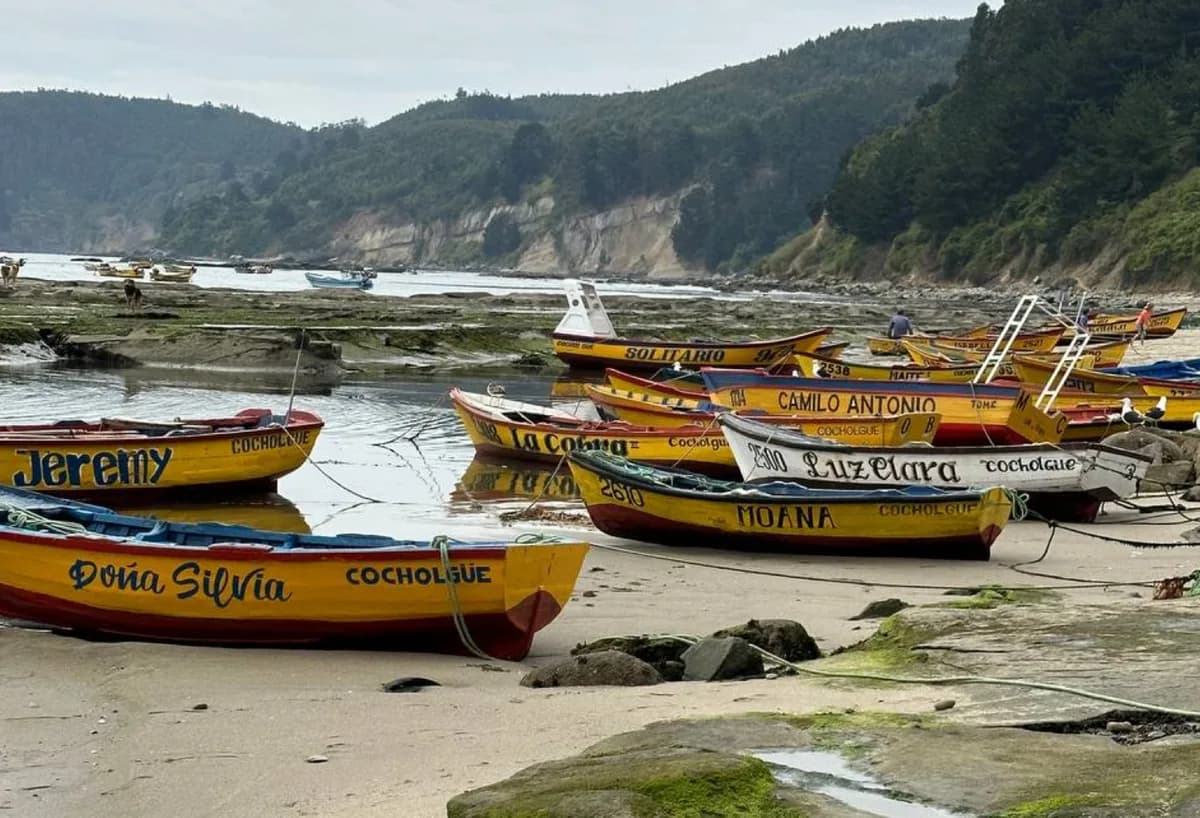
The road follows Lake Calafquén with Villarrica Volcano constantly in view. Coñaripe is quieter and less commercial than Pucón.
Cochelue Beach stands out for its dark volcanic sand, shaped by past eruptions of Villarrica. A hidden cave-like rock passage opens directly onto the beach, adding a subtle sense of discovery.
Pucón sits directly beneath Villarrica Volcano, one of the most active volcanoes in South America. Locally, the Mapuche people call it Ruka Pillán, meaning "House of the Spirit." In Mapuche belief, Pillán is a powerful ancestral force that lives inside the volcano. Historically, eruptions were seen as a sign of the spirit's anger. Even today, there's a visible respect toward the mountain among locals.
Villarrica has erupted multiple times in modern history, including in the 20th and 21st centuries. On some days, you can see smoke rising from the crater. At night, when conditions are right, a faint glow is sometimes visible. It's not just a scenic backdrop — it's an active geological presence.
With a rental car, you can drive to several viewpoints on the volcano. The road is accessible for normal vehicles (check conditions in winter). Altitude reaches around 1400 m; temperature can drop significantly even in summer.
Important: Even in summer temperature can drop to 5°C. Bring warm clothes.
Map: Termas Geométricas · Website & tickets
Location: 17 km from Coñaripe, deep in a narrow ravine. Access: By car only. Signal: Almost none — download offline maps.
The last section of road is winding and narrow. Not dangerous, but requires attention. After heavy rain, expect puddles and occasional loose gravel.
Parking is organized but can fill up during peak season. Go early. Not for aesthetics — for space. Once crowded, the narrow walkways feel tight.
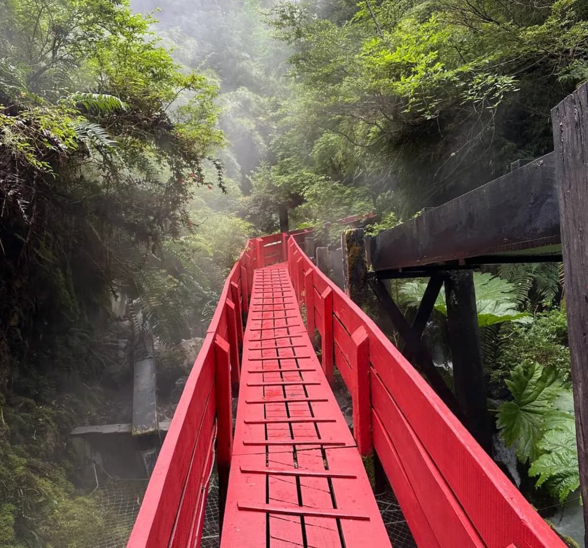
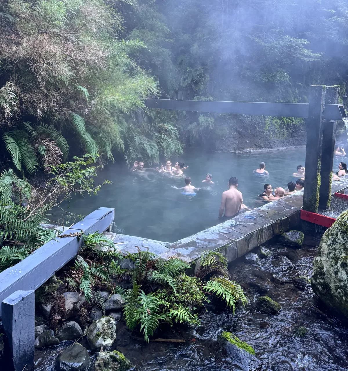
Termas Geométricas is not just a spa in the forest. It is one of the most architecturally intentional hot spring complexes in Chile.
It was designed by Chilean architect Germán del Sol, who wanted to preserve the wild ravine while creating a controlled experience inside it. Instead of flattening the land, the design follows the canyon's natural geometry — hence the name Geométricas.
Bright red wooden walkways cut sharply through dark green forest. The red walkway is about 450 meters long. The contrast is deliberate. The color was chosen so the structure would stand out against the vegetation and be visible in heavy fog or steam.
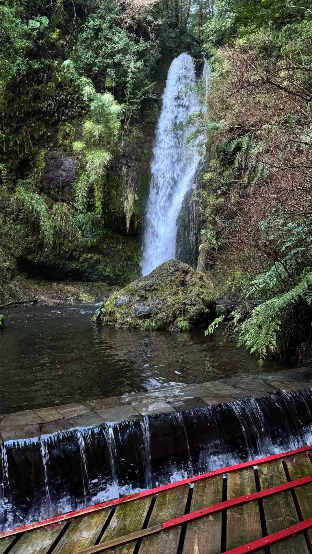
The complex includes approximately 17 thermal pools, with temperatures ranging between 36°C and 45°C depending on the pool and natural flow conditions. Each is fed directly from underground thermal sources heated by the Villarrica volcanic system. This entire area sits within a geothermal zone connected to the same tectonic forces that power Villarrica volcano.
That means:
The experience changes dramatically depending on weather: On a cold rainy day → steam fills the canyon, visibility drops, atmosphere becomes almost cinematic. On a hot summer day → the contrast between icy river water and hot pools is much stronger.
The narrow canyon creates natural acoustics. You constantly hear the cold river rushing next to you while sitting in hot water. This duality — ice and heat — is the core of the experience.
From a modern perspective, thermal waters in this region contain naturally dissolved volcanic minerals and provide sustained heat exposure. Warm immersion may help relax muscles, improve circulation, reduce stress, and ease mild joint stiffness. However, they are not medical treatments.
Prolonged exposure to high-temperature pools (above 40°C) is not recommended for people with cardiovascular disease, uncontrolled high blood pressure, recent heart conditions, or severe respiratory issues. Pregnant women should avoid very hot pools. Children should use lower-temperature pools and limit time. Alcohol consumption combined with hot water immersion increases risk of dizziness or fainting.
Typical safe practice is to limit immersion in hotter pools to 10–15 minutes at a time, followed by cooling periods.
The drive toward Puerto Fuy doesn't just change scenery — it changes atmosphere. The sky narrows. The road darkens under canopy. Moisture hangs in the air even on dry days. You enter the Valdivian temperate rainforest — one of the rarest forest ecosystems on Earth and one of the oldest living landscapes in southern Chile.
This is not decorative forest. It is layered, thick, biologically heavy.
Large parts of southern Chile were logged heavily during the 20th century. Native forests — including ancient Nothofagus (southern beech) forests — were cleared for cattle pasture, firewood, and commercial forestry (especially pine and eucalyptus plantations).
The land that is now the Huilo Huilo Biological Reserve was once part of this forestry frontier. At one time it was owned and managed by a forestry company. Rather than continuing traditional logging operations, the owners shifted strategy — choosing to protect and restore the native ecosystem.
This decision transformed what could have remained an area of timber extraction into one of the largest privately managed conservation reserves in Chile. The result is a mix of forest restoration, eco-tourism facilities, and conservation programs.
Huilo Huilo is private land, not a government national park — and this affects how it's managed and experienced:
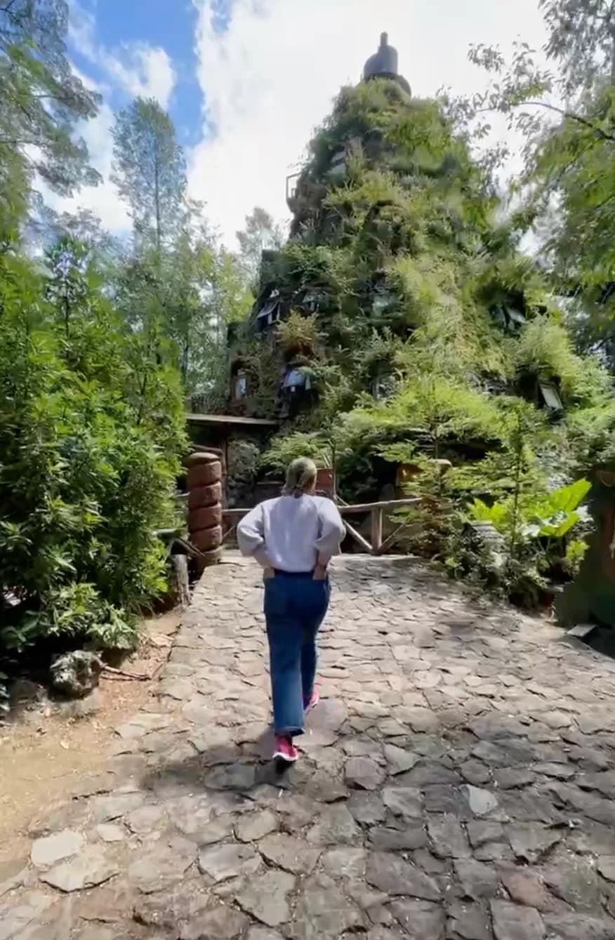
Huilo Huilo does not hide its ambition. The lodges are bold — sculptural wooden towers, curved balconies, facades textured like tree bark. Some visitors call it magical; others call it theatrical. The intention is clear: create immersion, not invisibility. Instead of minimal cabins, they built fantasy-scale structures rising directly out of the forest floor. It feels curated — but the forest itself does not feel artificial. That contrast is what makes the place interesting.
Step away from the architecture and the forest takes over. The Valdivian rainforest is:
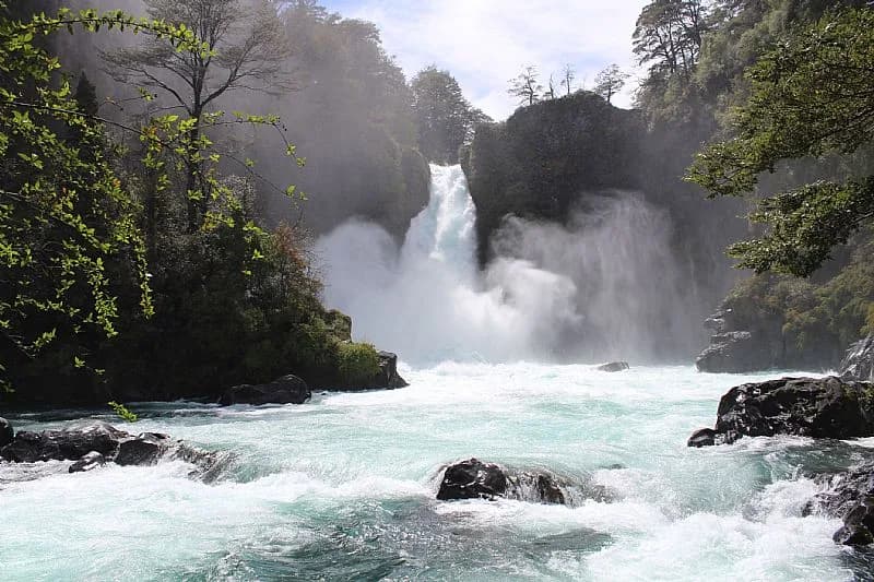
Wildlife includes pudú (the smallest deer in the world, shy and rarely seen), Magellanic woodpecker (large, striking black-and-red bird), and native amphibians adapted to cold, humid forest. The waterfalls inside the reserve — particularly Salto Huilo Huilo — are powerful after rain and accessible via maintained trails. Even at midday, light struggles through canopy. Sound feels muted. This is not Patagonia's open wind. This is enclosed green depth.
The name "Huilo Huilo" is often linked to Mapuche language roots. The region has long been Mapuche territory, and forest spirits — ngen — are part of traditional belief systems. The rainforest was never considered empty land. That cultural layer sits quietly beneath the modern eco-tourism project.
Book accommodation and excursions: Huilo Huilo (Linktree) · Instagram: @huilohuilo_reservabiologica
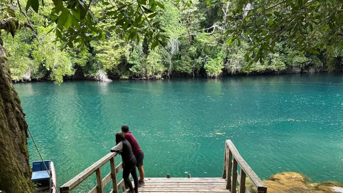
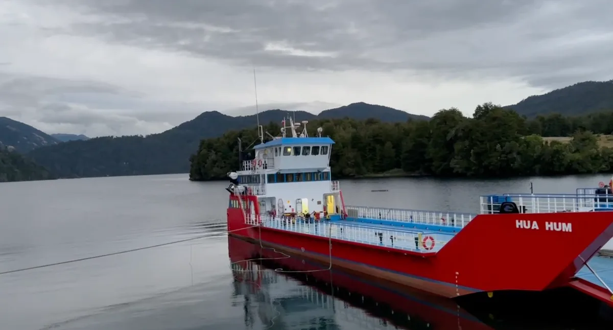
Puerto Fuy sits on Lake Pirihueico, surrounded by mountains and forest. It is minimal — dock, water, a handful of buildings. But it functions as a strategic border point. From here, ferries cross toward Argentina through one of the quieter Andean crossings. It avoids long mountain detours and major commercial traffic routes. Because it is not a large border like Paso Los Libertadores, it feels almost informal. It is not. Do not underestimate the bureaucracy.
VERY IMPORTANT for rental cars: You must request cross-border permit in advance. Without it → you will not be allowed to enter Argentina.
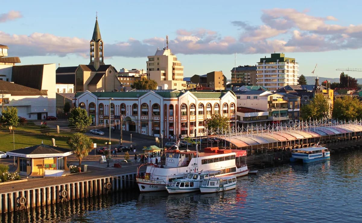
The drive into Valdivia is simple and well signposted. As you approach, the landscape opens into river plains rather than coastline. This is a river city first — the ocean is nearby, but the rivers define it.
Valdivia sits at the confluence of several waterways, which historically made it strategically important for both Spanish colonists and later European settlers.
Magnitude 9.5 — strongest ever recorded in human history.
On May 22, 1960, Valdivia became the epicenter of the most powerful earthquake ever measured.
What happened:
One of the most dramatic moments came after the quake: a massive landslide blocked Lake Riñihue upstream, threatening to burst and flood Valdivia entirely. Engineers, soldiers, and civilians worked urgently to dig channels and lower the water level. That operation — known locally as El Riñihuazo — is still remembered as a moment when the city narrowly avoided total destruction.
Even today, older residents speak about: the ground "moving like waves," boats thrown inland, the river rising suddenly.
You'll notice the city feels layered — modern structures next to rebuilt zones. That's not coincidence. Much of Valdivia is post-1960 reconstruction. For visitors, this history adds context. The calm riverfront you see today was once chaos.
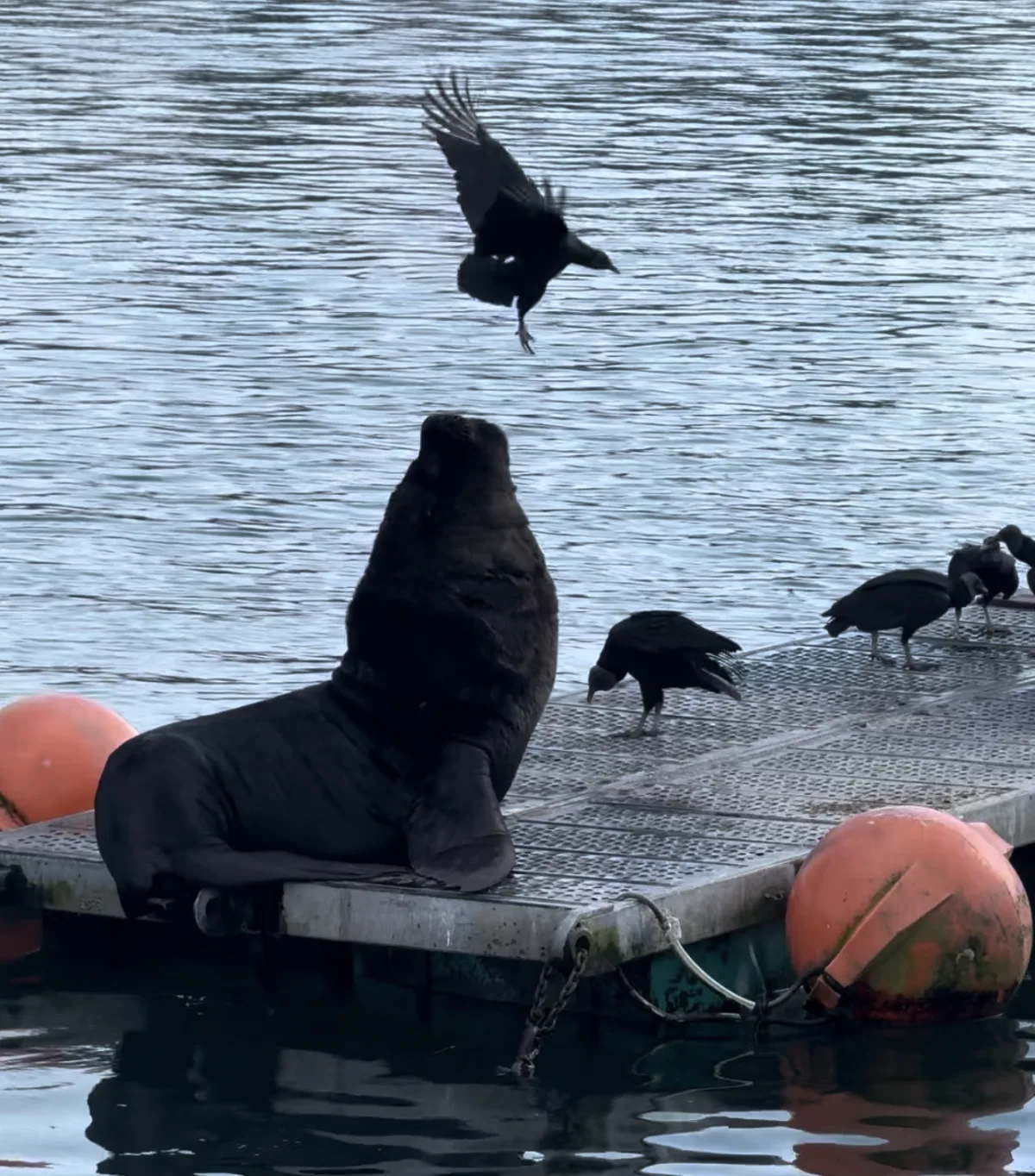
Valdivia's most active area is along the river near the Mercado Fluvial (fish market). This is where the city feels alive: fishermen unload fresh catch; sea lions gather beneath the docks; pelicans wait overhead; vendors sell seafood directly from stalls.
The sea lions are large South American sea lions, not small coastal seals. They can weigh over 300 kg and are loud, territorial, and fully integrated into the market ecosystem. They wait for fish scraps and occasionally compete with pelicans. This is not a staged tourist attraction. It's daily life.
One of the best ways to understand Valdivia is from the water. River tours typically last 1–2 hours and take you through the Valdivia River, surrounding wetlands, Isla Teja, and along historic riverbanks. From the water you notice things you'd miss from shore — wooden stilt houses leaning over the current, forested edges dropping into the river, old industrial structures slowly being reclaimed. Cormorants line the rocks; occasionally an otter surfaces in quieter stretches.
Some tours head toward Corral Bay and the old Spanish fort system — reminders that Valdivia was once one of the most fortified cities in South America during colonial times.
The rivers connect directly to the Pacific, which is why marine wildlife — sea lions, pelicans, cormorants — lives this deep inside the city. It's unusual, and it's one of the things that makes Valdivia feel unlike any other Chilean town.
Map: Isla Teja · Map: Parque Saval
Across the bridge from downtown, Isla Teja feels more residential and calm. Parque Saval is a large green space with walking paths, open lawns, and quiet river views. In season, lotus flowers bloom across the lagoons. This area is less commercial and gives a better sense of everyday life in Valdivia.
Driving southwest from Valdivia along Ruta T-350 shifts the environment quickly. The road becomes more rural, passing: small farms, dense temperate forest, occasional coastal villages. Eventually, the Pacific appears — wide, dark, and exposed.
This coastline is: windy most afternoons, cold year-round, largely undeveloped. Black sand beaches stretch long distances with minimal infrastructure. It's not a swimming coast; it's a viewing coast. Traffic is light. Services are limited. Plan fuel accordingly.
A rural viewpoint outside the city offering open horizon views over forest and ocean.
Important driving notes:
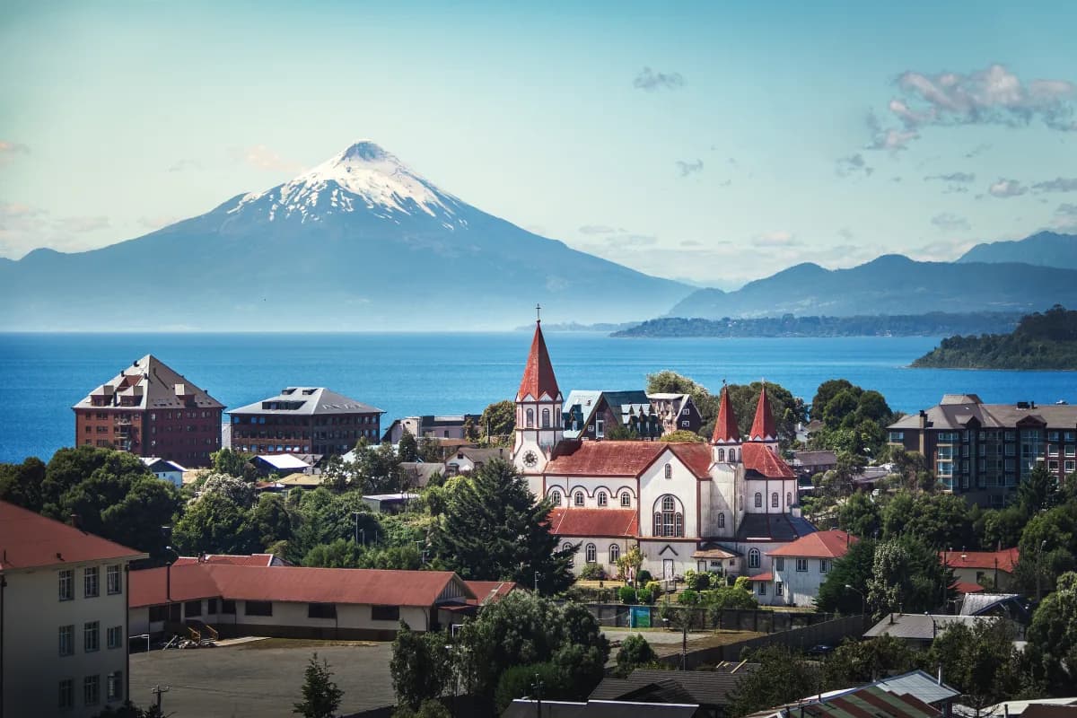
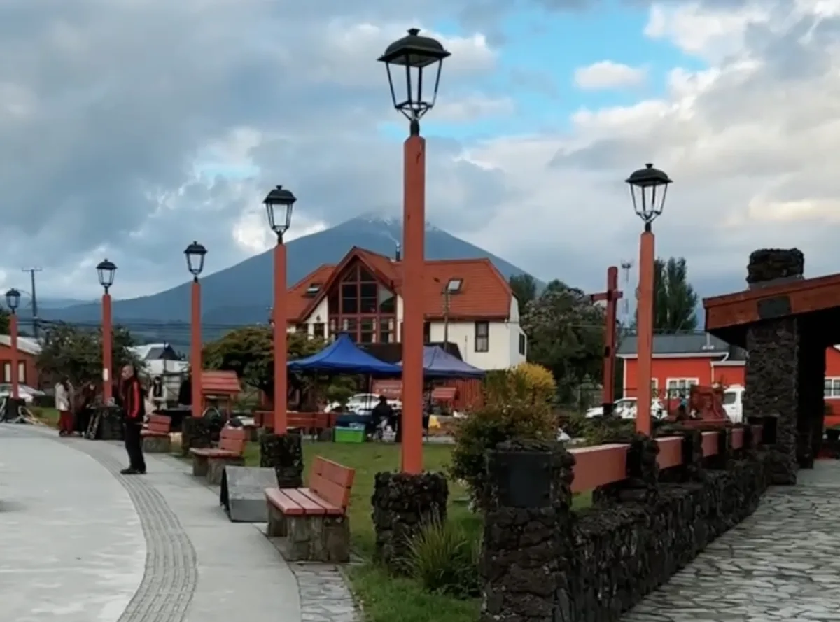
After Valdivia, Frutillar feels noticeably more ordered. The town is small, but it's intentional — houses are maintained, gardens are structured, and the lakeside promenade is clearly designed as a focal point.
Frutillar was founded in the mid-19th century by German settlers invited by the Chilean government to develop southern regions. Unlike Valdivia, much of its settlement pattern remained intact, which is why the architectural influence is still visible — especially in older wooden houses with steep roofs and front gardens. This is not a theme-park version of Europe. It's a Chilean lakeside town with visible Central European roots.
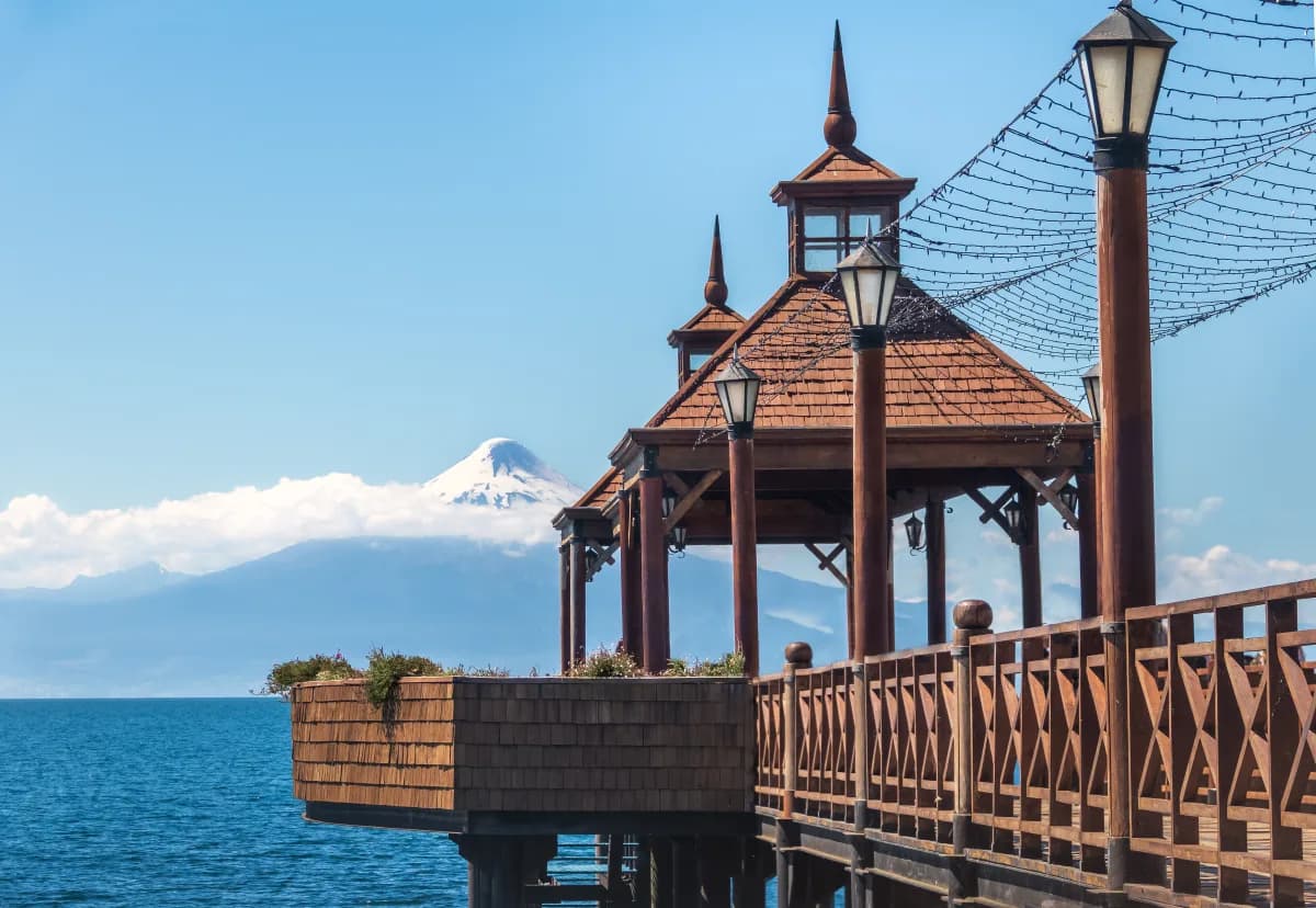
The power of Frutillar is its setting. It sits directly on Lake Llanquihue, Chile's second-largest lake, with Osorno Volcano positioned almost perfectly across the water. On clear mornings, the volcano reflection is extremely sharp. Wind typically increases in the afternoon, so the best lake conditions are early. The lakeside walkway is flat and easy to explore on foot. The town center is compact; you can park once and walk.
This is not just a local theater — it's one of the most important performing arts centers in southern Chile. The building sits directly over the water, and its main hall has floor-to-ceiling windows facing Osorno volcano. Even if you don't attend a performance, the exterior positioning gives one of the cleanest framed views of the volcano anywhere around the lake. It's modern, minimal, and intentionally aligned with the landscape.
Driving around Lake Llanquihue from Frutillar to Puerto Varas takes under an hour. Puerto Varas is larger, more commercial, and clearly tourism-oriented. More hotels, more restaurants, more visible activity. It's the operational hub of the lake region. But the real reason to come here is access to Osorno Volcano.
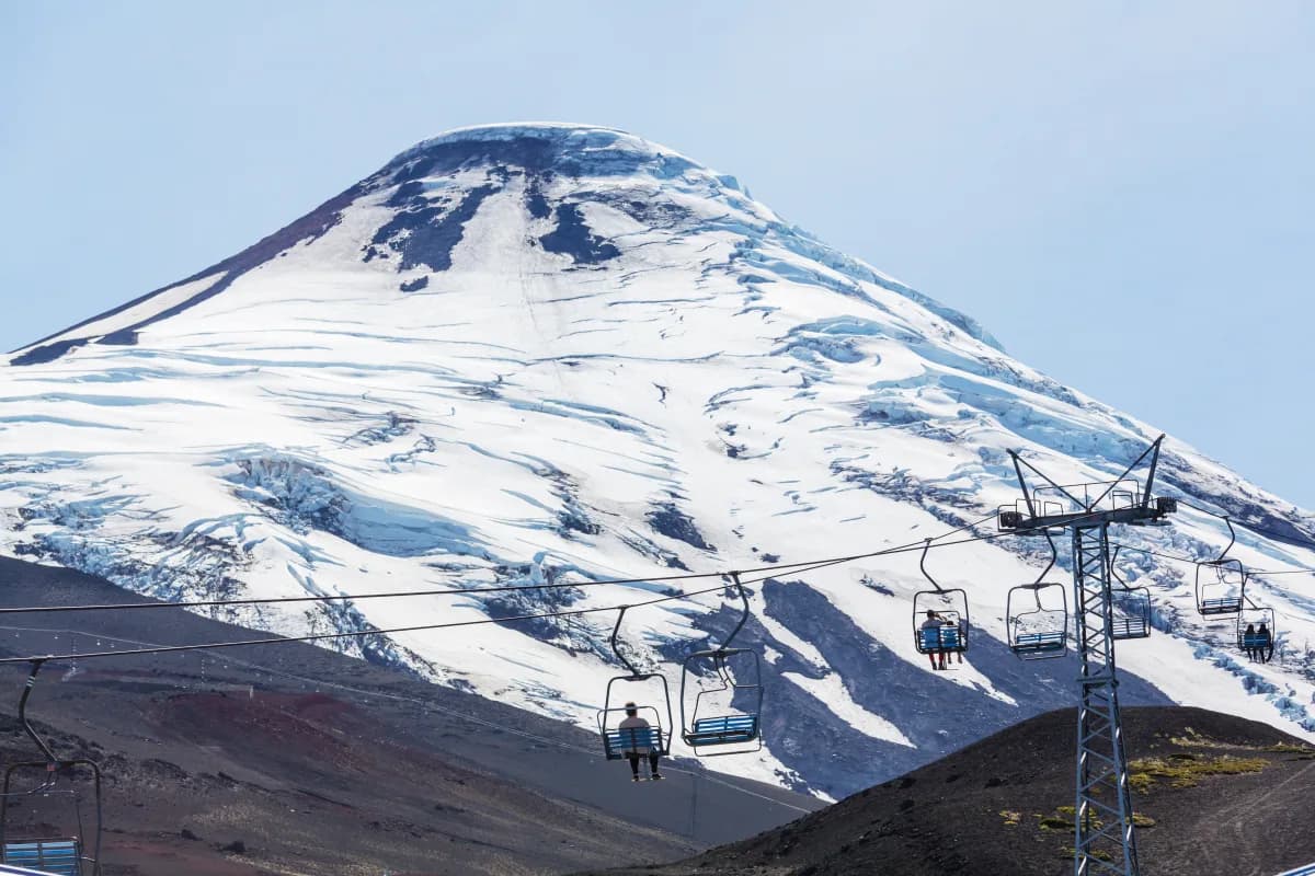
Map: Osorno Volcano · Tickets (Centro Volcán Osorno)
Osorno looks almost mathematically perfect. The symmetry is why it's often photographed. It's one of the cleanest cone shapes in the Chilean Andes.
The road up is fully paved and manageable with a normal car in standard weather conditions. The ascent is steady and well engineered — no need for 4x4 unless winter snow is heavy. As you climb: the vegetation thins; volcanic rock becomes more visible; Lake Llanquihue expands below you. At the upper ski center area, you reach a plateau with parking and lift access.
Lift access starts around 19,000–33,000 CLP per person depending on sections. Prices change seasonally — confirm on site or check the official website before going.
It typically closes around 18:00. Arriving after 16:00 risks missing the last ascent.
From the upper lift station, you can walk short paths across volcanic terrain. This is not a technical hike — it's controlled access to higher elevation viewpoints.
Funicular closes around 18:00. Arrive early. Road accessible with normal vehicle.
Map: Puerto Montt · Map: Puerto Natales
At this stage of the journey, geography becomes the dominant factor.
South of Puerto Montt, Chile stretches into long, fragmented terrain defined by fjords, channels, and remote road systems. Continuing overland toward Torres del Paine is possible, but it requires significant time, multiple ferry crossings, and flexible scheduling.
For itineraries focused on Torres del Paine rather than long-haul transit, air travel is the most efficient transition.
The direct flight from Puerto Montt to Puerto Natales takes approximately two hours and bypasses several days of overland travel.
If the vehicle is not continuing south, it can remain secured in Puerto Montt while the Patagonia section is completed.
This transition effectively separates: the Lake and Volcano region from the Patagonian steppe and glacial zone.
The environmental shift is immediate. Forested lake landscapes give way to open plains, strong prevailing winds, and a more exposed climate.
Even during summer months, wind significantly lowers perceived temperature. Wind-resistant outer layers are more important than heavy insulation.
Even in summer — extremely cold in Patagonia.
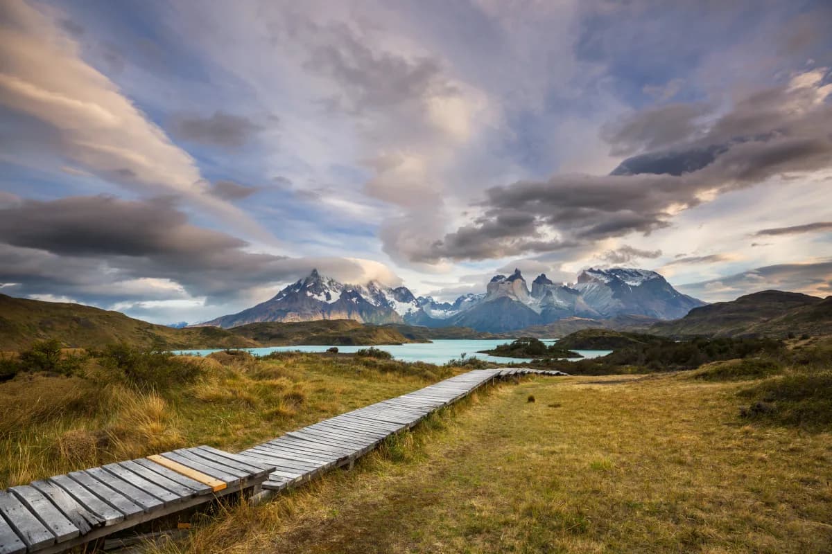
Map: Torres del Paine National Park · Park passes (Pases Parques)
Before hikers and Instagram, this was sheep territory. Large estancias (ranches) dominated the region in the late 19th and early 20th centuries. Indigenous Aónikenk people had already been pushed out or absorbed into settler systems. Torres del Paine only became a protected area in 1959. Even then, protection was weak. There have been major human-caused fires that burned tens of thousands of hectares. If you notice large sections of grey tree skeletons, that's not natural aging. That's recent history. The landscape people call "wild" has already been damaged — and partially recovered.
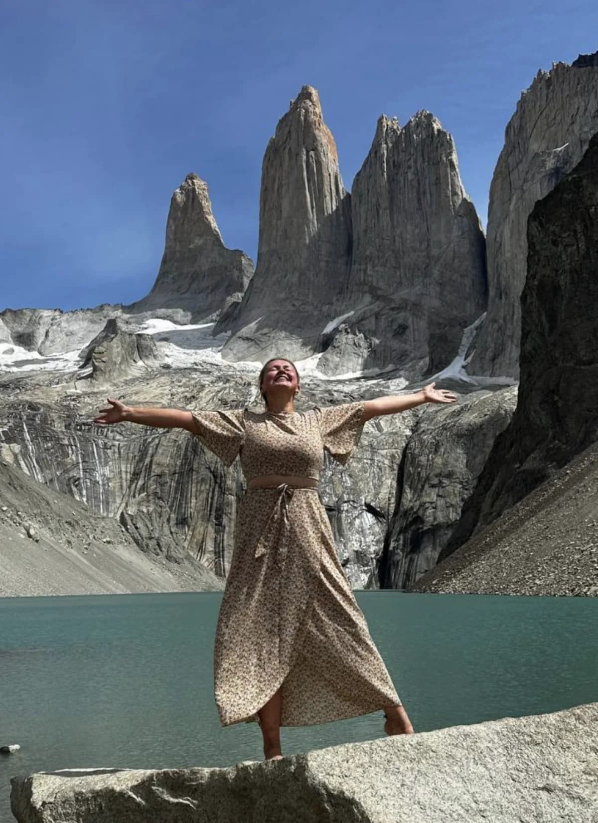
The three famous towers are not peaks shaped by slow erosion alone. They are granite that cooled underground millions of years ago. Softer sedimentary rock surrounded them. Glaciers later carved the sediment away, leaving the hard granite exposed like bones after flesh is removed. You are literally looking at the inside of a mountain. That's why the surfaces look raw and vertical.
The wind in Torres del Paine is not occasional weather. It is structural. Air from the Pacific slams into the Andes and is forced upward. Pressure differences accelerate it across the Patagonian plain. Gusts regularly exceed 80 km/h. You open your car door and feel resistance. You hike and lean forward without realizing it. On certain days, trekking is less about endurance and more about balance.
Official distance: 23 km. Most people's GPS: closer to 28–30 km. The first section is gradual. The last stretch is steep, rocky, exposed. If wind is strong, the final kilometer can feel twice as long. On clear days, the granite turns orange at sunrise. That light lasts minutes, not hours. Timing matters.
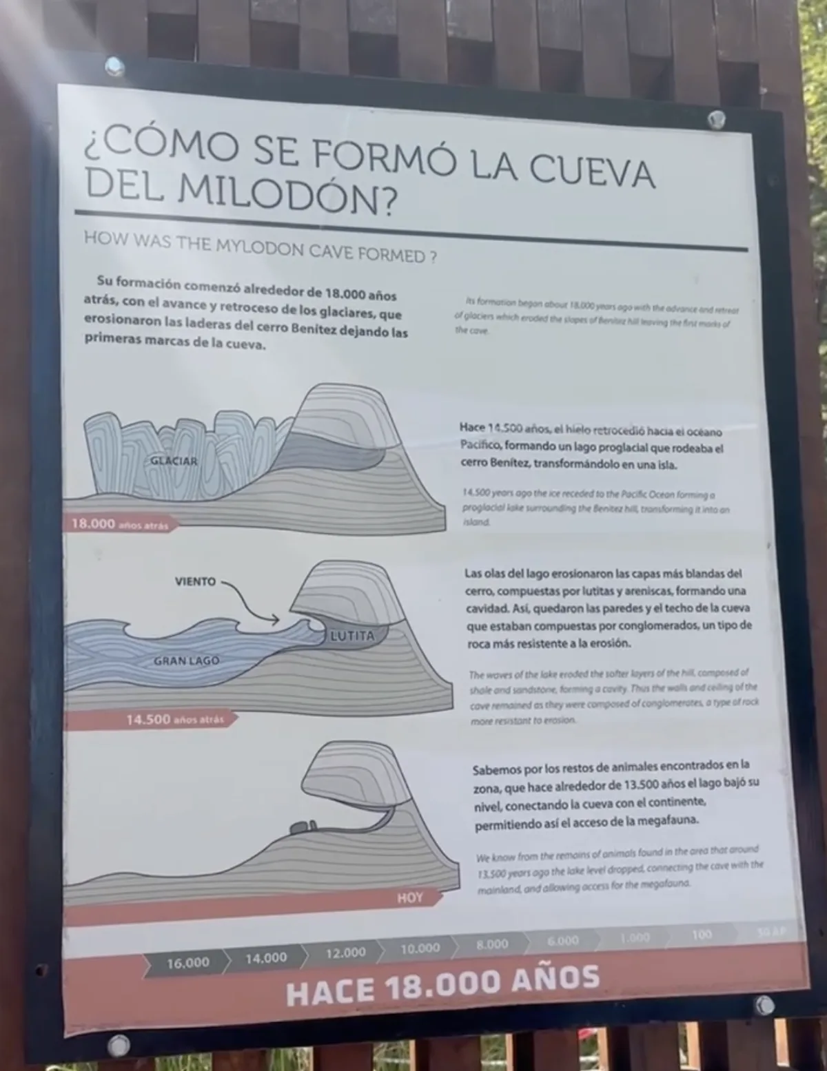
Before you even enter the park, the Milodón Cave sets the tone. In 1895, pieces of skin and bone from a giant ground sloth were discovered here. For months, newspapers speculated the animal might still be alive somewhere in Patagonia. Imagine that: late 19th century explorers genuinely considering that a prehistoric creature was hiding in these valleys. It tells you how unexplored this region once was.
You will see guanacos everywhere. Calm, upright, watching. What you won't see easily is what watches them. Torres del Paine has one of the highest concentrations of pumas in the Americas. Local ranchers once hunted them heavily to protect livestock. Today they are protected, and specialized wildlife tours track them at dawn. Most visitors never notice how close they might be.
Most first-time visitors get their postcard view here. On a calm morning, the towers reflect perfectly. On a windy one, the surface fractures into metallic ripples. The name "Amarga" (bitter) refers to mineral content in the water. It's not poetic — it's chemical.
Torres del Paine has several major lakes — Lago Grey, Pehoé, Nordenskjöld, Sarmiento, Laguna Amarga, and others. Lago del Toro is the largest. It lies in the western part of the park. That almost fluorescent blue isn't "clear water." It's glacial sediment suspended in meltwater — crushed rock so fine it reflects light differently. That sediment comes from glaciers grinding mountains into powder. The color is geology in motion.
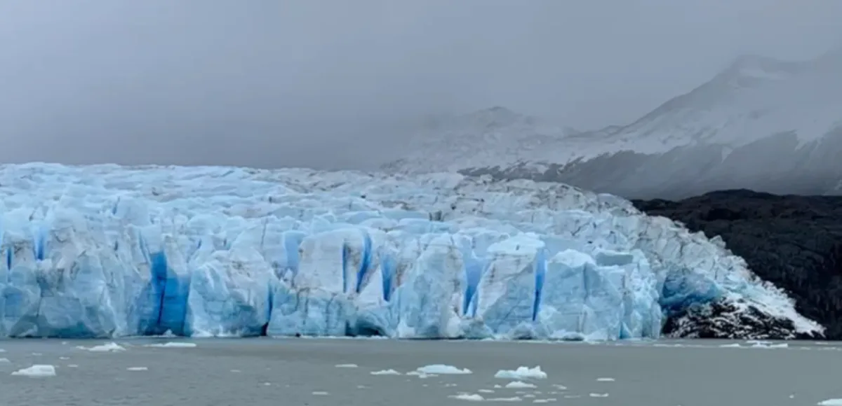
Map: Hotel / Grey glacier tickets
Grey Glacier is part of the Southern Patagonian Ice Field, one of the largest non-polar ice masses on Earth. The ice you see at the front of the glacier may have formed decades ago, compressed layer by layer by snowfall. When chunks break off and fall into the lake, the sound is not cinematic — it's violent. Deep cracking, echoing across water. It reminds you the glacier is not frozen scenery. It is active mass.
Boat to the glacier: Payment at the departure point is by card only.
There are NO gas stations inside Torres del Paine. Nearest fuel can be ~120 km away.
Always: Fill full tank before entering. Carry extra fuel canister. This is not optional advice.
After Patagonia, many travelers fly back to Puerto Montt and pick up their rental car to begin the Carretera Austral — a separate overland route running south through Chile's fjord and forest interior. The Marble Caves, the final destination of this section, are reached on this leg.
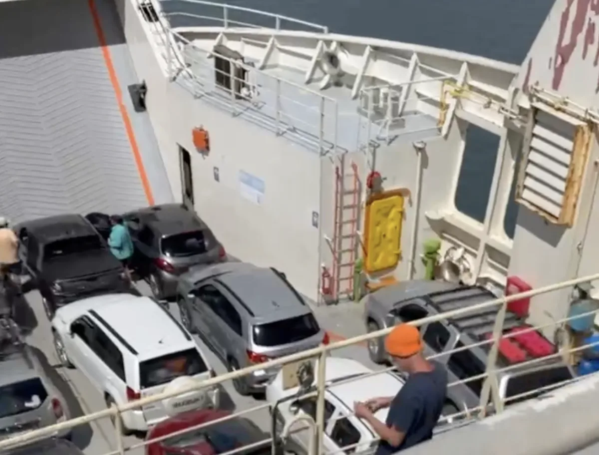
South of Puerto Montt, Chile stops behaving like a normal country. The highway disappears into water, and the only way forward is to put your car onto a ferry.
This isn't a scenic cruise. It's logistics. Trucks, supply vans, local families — everyone moving because this is the only route. Ferry schedules are limited, sometimes once per day depending on the stretch and season. Missing one can mean losing a full day. In high season, advance booking is not optional.
Book ferries: Somarco (Hornopirén – Caleta Gonzalo) · Naviera Austral
Once the ferry pulls away, the geography changes instantly. Forested mountains drop straight into deep channels. There's no gentle coastline here. It's steep, humid, and compressed — fjord-like terrain that feels closer to southern Norway than to the Chile most visitors know.
Hornopirén is small and functional. No curated charm. Just wooden buildings, damp air, and a sense that you are entering a region that developed late and slowly.
From here, the Carretera Austral stretches south — a road that took decades to build because of landslides, isolation, and extreme terrain. Parts are paved. Parts remain gravel. Sections narrow without warning. You drive carefully because this road demands attention. And that's exactly why it's memorable.
This stretch isn't dramatic in the Torres del Paine sense. It's expansive and repetitive — and that repetition becomes hypnotic.
You drive beside fast, glacial-fed rivers that glow turquoise from suspended sediment. In summer, tall lupines line the roadside in thick purple waves. Waterfalls appear unexpectedly around bends. Deer sometimes cross at dusk. Traffic can disappear for long stretches.
There are no large service areas. No polished viewing platforms. No constant cafés. It's just road, forest, water, and sky. And you realize the road itself is the attraction.
Puyuhuapi feels remote in a way that isn't staged. Founded by German settlers in the 1930s, it carries subtle traces of that heritage — steep roofs, wood construction, practical design for heavy rain. It's small. Quiet. Efficient. You don't "tour" Puyuhuapi. You pause there.
Coyhaique is the last proper urban anchor before things thin out again. Fuel stations, mechanics, supermarkets — this is where you prepare. Distances ahead are long. Services are spaced. You don't improvise in Aysén.
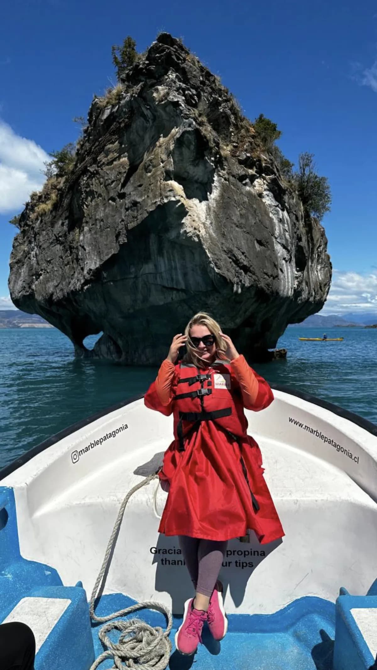
At the end of this route lies one of the most distinctive natural landmarks in Chilean Patagonia — the Marble Caves, located on the shores of Lake General Carrera.
The lake itself is vast, shared with Argentina (where it is known as Lake Buenos Aires), and often feels more like a sea than a lake. Weather conditions play an important role here. Winds can rise quickly, and calm mornings may turn rough by afternoon.
The caves are not visible from the road and cannot be accessed on foot. To visit them, you must travel by water from the small town of Puerto Río Tranquilo.
Parking near the departure areas is generally simple. All departures depend on weather conditions, particularly wind and wave levels on the lake.
Book a boat tour: Marble Patagonia
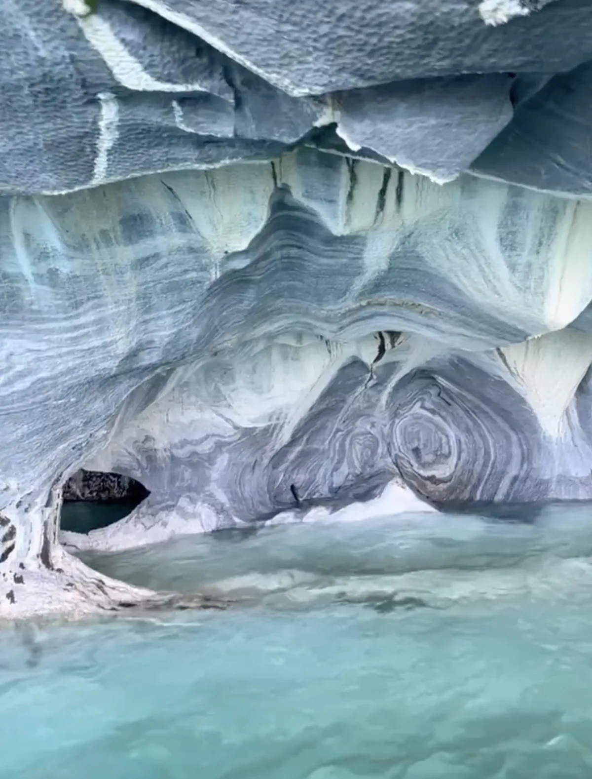
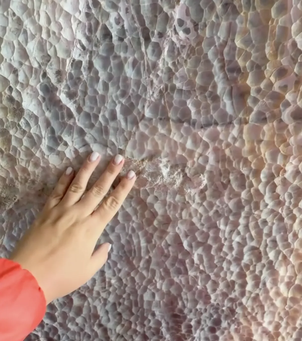
The formations are carved from solid calcium carbonate marble by thousands of years of wave erosion. Constant water movement has shaped the rock into smooth, almost architectural forms — arches, domes, curved ceilings, and hollowed chambers that feel deliberately sculpted.
But the true magic is the light.
Lake General Carrera carries fine glacial sediment that gives the water its intense turquoise color. That color reflects upward into the pale marble walls, transforming the caves into glowing shades of electric blue. On sunny days, the effect is almost surreal — bright, luminous, and saturated. On cloudy days, the tones shift to cooler blues and silvery metallic hues.
The caves aren't massive cathedrals. They're intimate, almost immersive. You drift through them slowly by boat, and with every change of angle or ripple in the water, the color transforms. It's not just a landscape — it's a living light show shaped by geology and time.
Despite the quality and purity of the calcium carbonate marble, the Marble Caves have never been developed as an industrial quarry. In Chile, the site is officially protected as a Santuario de la Naturaleza (Nature Sanctuary), where extraction is strictly prohibited. Swimming inside the caves is also not allowed or recommended. As a protected area, activities are regulated to preserve the fragile formations. In addition, Lake General Carrera has extremely cold glacial waters year-round, and sudden winds can quickly create strong waves. There are no lifeguards or designated swimming areas near the caves, making entry into the water unsafe.
After visiting the Marble Caves, you realize this marks the final destination before the return to Santiago. The weeks pass quickly — long drives, remote landscapes, and constant movement make the time feel compressed.
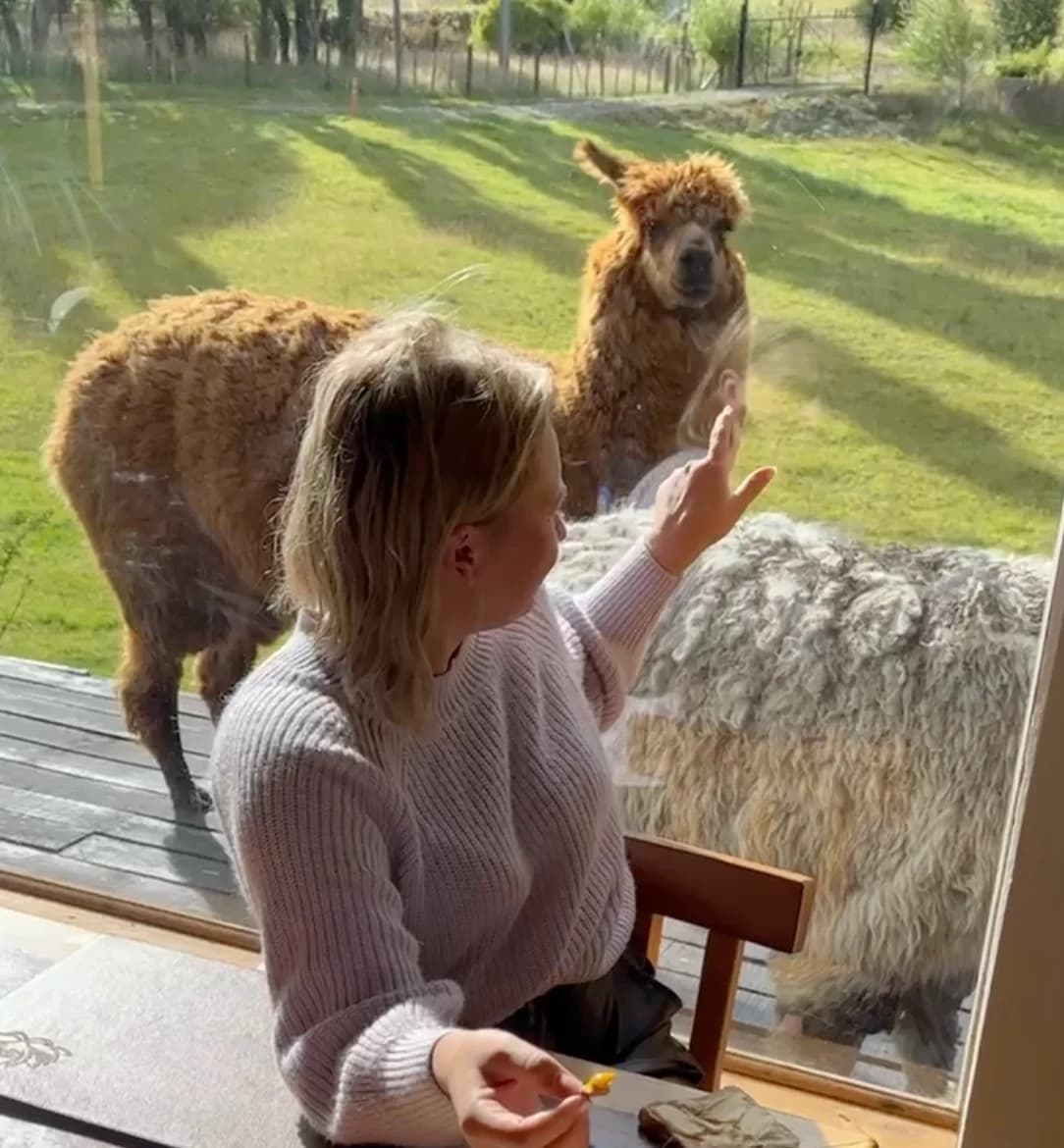
Before starting the drive north, you can spend one final night in a very isolated house. The location is completely remote — no nearby towns, no traffic, just mountains and open land.
In the morning, alpacas may be standing outside the house. While alpacas are most commonly associated with northern Chile's Altiplano, small herds are sometimes kept by rural families in southern Chile as well. Originally domesticated thousands of years ago by Andean indigenous communities for their soft, warm wool, they remain calm herd animals well adapted to cold climates. Today, alpaca fiber is still widely used in clothing and textiles across Chile.
Once you begin driving north, the landscape gradually changes. The open Patagonian terrain slowly transitions into greener valleys and more populated areas. The return journey is long, so you can divide it into manageable stretches, making several short stops along the way to rest and refuel.
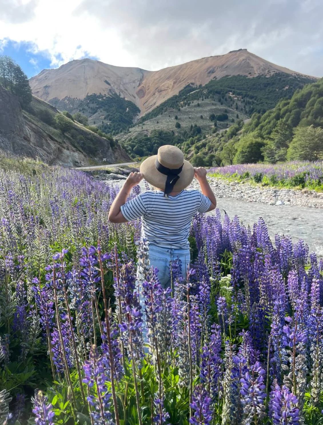
Around 22 hours from Santiago, you may pass a wide field of lupine flowers stretching across the roadside with mountains rising behind it. It may not be a planned stop — just one of those places you notice immediately and decide to pull over. After days of remote wilderness, it can feel like a quiet final highlight of the trip.
From there, the drive continues in stages, with practical overnight and rest stops along the way. The final stretch back to Santiago marks the end of a full month on the road.